Desert View Drive Overlooks in Grand Canyon National Park
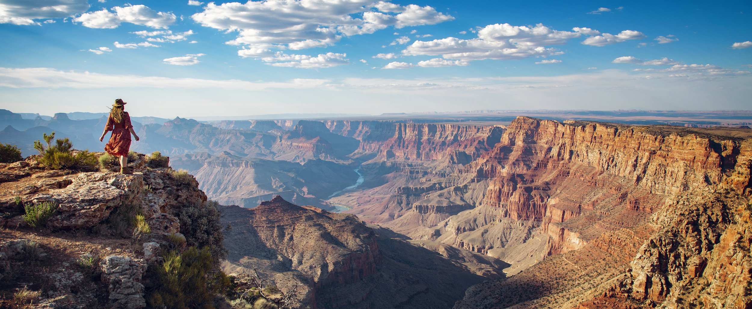
Hi friends! This week we’re taking an incredible trip along the South Rim of Grand Canyon National Park. Desert View Drive offers incredible viewpoints that don’t require taking a shuttle (unlike Hermit Road for most of the year). Join me as we take a drive and visit each of these Grand Canyon overlooks along Desert View Drive.
Shoshone Point in Grand Canyon National Park
Location
The section of highway we’re exploring this week is found along Route 64 starting at the Grand Canyon Village and culminating at the Desert View Watchtower about 25 miles away. Desert View Drive hugs the South Rim in Grand Canyon National Park and boasts some of the most spectacular clifftop scenes in the region. Out of the 9 named spots we’ll be driving to today, 7 of them have available parking right next to the scenic overlooks, making this a great option for families and folks that don’t want to do much hiking. However, for the hikers out there (don’t fret!), there are plenty of trails to enjoy on this side of the park as well. Continue reading below for details on each Desert View Dr location.
Pipe Creek Vista along Desert View Drive in Grand Canyon
Looking back towards Mather Point from Pipe Creek Vista
Pipe Creek Vista
This is the first pullout on the left as you head east from the Grand Canyon Village along Desert View Drive. It can be reached by private vehicle or by the free Kaibab/Rim (Orange) Route shuttle bus, which departs from the Visitor Center Shuttle Bus Terminal. Located just steps away from the parking spots, the views here are framed by Mather Point and Yaki Point, and you get a unique view of the Douglas fir forest here. It’s also an excellent stop for birding, especially in the Spring and Fall during the major migrations.
Yaki Point seen from Pipe Creek Vista in Grand Canyon
Yaki Point
Yaki Point is the first of two stops along Desert View Drive that you can’t drive right up to. If you’d like to enjoy views from this spot, you have two options. The first is to take the free Kaibab/Rim (Orange) Route shuttle bus from the Visitor Center. Make sure to check the official NPS website for the most up-to-date departure times. The other option is to park at Pipe Creek Vista and hike or bike in from there, which is about 1.5 miles one-way.
Along the ridge to Yaki Point is the trailhead for the South Kaibab Trail. This well-maintained dirt path has numerous day and multi-day hike options. Take it to the popular Ooh Aah for 1.8 miles RT with almost 800 ft in elevation change...or for the serious hikers, take it all the way to Skeleton Point for 6 miles RT with over 2000 ft in elevation change.
Shoshone Point in Grand Canyon National Park
Shoshone Point rock formation
Shoshone Point
Our next stop is the second viewpoint we’re visiting today that takes a bit of hiking to reach. The trailhead to Shoshone Point is located off Desert View Drive, where you’ll find an unmarked dirt parking lot. This out and back trail is just over 2 miles roundtrip and leads you to breathtaking panoramic views, highlighted by a unique rock formation perched at the cliff’s edge. Shoshone Point is free of guard rails, making the for endless open views, but it is important to explore within your own personal skill and comfort level along the jagged cliffs here. There is also a picnic area nearby with restrooms and a covered picnic pavilion with tables and grills.
For more information on this hike, check out my full Shoshone Point blog post.
Duck on a Rock Viewpoint along Desert View Drive
Duck on a Rock Viewpoint
Continuing on, you reach a unique Kaibab formation, which resembles (you guessed it) a bit of a rubber ducky...and the backdrop is pretty stunning too! The word Kaibab comes from a Southern Paiute word, meaning mountain laying down. The Grand Canyon was formed under a shallow inland sea long ago, and it’s comprised of various sedimentary rocks, including limestone and sandstone layers, both of which you can see from the spot.
Grandview Point along the South Rim of the Grand Canyon
Colorado River seen from Grandview Point
Grandview Point
Located down a short drive off the main highway, Grandview Point is where the historic Grandview Trail begins, which was built originally as a mining route in 1893. It’s an incredibly treacherous and steep trail, often only recommended for experienced hikers. Grandview Point owes its fame to the Last Chance Mine, which is located 3000 feet below and produced rich copper until 1907. This viewpoint does indeed offer “grand views” from east to west along with the Colorado River flowing below.
Grand Canyon seen from Moran Point
Moran Point along Desert View Drive in Grand Canyon
Moran Point
Our next stop was named for the famous 19th Century landscape painter, Thomas Moran, whose work helped spur on the creation of several of our national parks. From this view, the Grand Canyon‘s topography (and geology) is highlighted as you can clearly see all three of the park’s main rock groups: metamorphic basement rocks, Precambrian Grand Canyon Supergroup, and Paleozoic strata.
Grand Canyon & Colorado River seen from Lipan Point
Grand Canyon views from Lipan Point
Lipan Point
About 6 miles down the road you hit one of my favorite spots along Desert View Drive. Located down another short drive off the main highway, Lipan Point boasts some of the most expansive sights from the South Rim with clear canyon views to the west, making this a popular spot to enjoy sunset. The Colorado River can also be clearly seen at this overlook as it cuts through the canyon layered with a wide aray of colors and textures below.
Grand Canyon & Colorado River seen from Navajo Point
Colorado River seen from Navajo Point in Grand Canyon National Park
Navajo Point
One of the highest vistas along the South Rim, Navajo Point boasts views of the Colorado River snaking its way through the canyon...and with the panoramic views, it’s another amazing Arizona sunset spot. Sunset anywhere in the Grand Canyon is wonderful, but here the rock faces of the canyon walls burst with color as the long cool shadows cast across the valleys below.
Desert View Watchtower seen from Navajo Point
Desert View Watchtower in Grand Canyon National Park
Desert View Watchtower
Finishing off our adventure today is the Desert View Watchtower. Just east of Navajo Point, this beautiful structure was designed by architect Mary Colter and completed in 1932. The seven story structure was modeled after structures from the Puebloan people of the Colorado plateau, and it has been designated a National Historic Landmark. Currently the tower is closed until further notice for restoration efforts...however, the ground level (View Room) is open daily from 8am-7pm.
There are also several amenities found at this spot, including restrooms, food options, and a gas station. Of course the Grand Canyon views from here are quite spectacular as well!
Grand Canyon views from Lipan Point along Desert View Drive
Know Before You Go
• Consider visiting the above mentioned spots for sunrise (or early in the morning) for the canyon’s incredible color show and to avoid large crowds and the heat.
• At the several viewpoints you may see coins, food, or paper money tossed and sitting on the outstretched cliffs. Please do not litter or throw coins/money here. It is incredibly unsafe for the local wildlife...in fact, a California condor died here after swallowing coins.
• Please remember to follow all the Leave No Trace Principles on your visit.
• While much of the North Rim closes for Winter due to snow, the South Rim of the park remains open year-round, so these spots can be viewed in all four seasons. Make sure to check the official NPS website for the most up-to-date road conditions and closures prior to visiting.
• While some of these viewpoints have protective guard rails to keep you safe, multiple views are completely unobstructed and wide open with sheer drop offs. Please explore at your own skill and comfort level.
• Wildlife is abundant in the park – from rattle snakes and tarantulas to deer and elk. Please remember to give wild animals plenty of space as we are guests in their home, and never leave food unattended. Unfortunately people often approach or try to feed the friendly looking squirrels here...please do not do this! Not only is it unhealthy for them to stop foraging for their natural food sources, they can scratch or bite unexpectedly while carrying many diseases (including the plague)...so stay safe and keep your distance.
• Hiking in this park is a wonderful experience, but the Grand Canyon is prone to inclement weather. Take time to understand the weather patterns here. Dehydration is the biggest safety issue for hikers in the park. Make sure you have plenty of water, sunblock, a wide-brimmed hat, and consider hiking early in the day to avoid heat related illness in the hot Summer months.
Top 10 Things to Do in Grand Canyon National Park
Desert View Drive
Desert View Watchtower
Bright Angel Trail
Ooh Aah Point
Lipan Point
Mojave Point
Powell Memorial Point
Navajo Point along Desert View Drive in Grand Canyon National Park
In Summary
Thanks so much for joining me this week in Grand Canyon National Park. For a virtual visit of each of these Desert View Drive viewpoints, make sure to watch my full Behind the Blog video at the top of this post, or watch it on YouTube here. Until next week, I hope you find adventure and encouragement wherever you go!
Navajo Point views at sunset in Grand Canyon National Park
If you enjoyed this post, you might also like…
About Me
I’m Dawn Marie, a travel and lifestyle blogger based out of Southern California. With in-depth articles, travel guides, and reviews on hotels & products, I seek to share my journeys to help you plan for your own. My adventures take me all over California, the western United States, and around the globe...and every Monday I post new content here, including a comprehensive blog post and YouTube video.
Search the Blog
Featured Posts
Etsy Shop


Plan the perfect day trip to Saguaro National Park! Check out this 1 day itinerary, which includes 10 top spots to visit in Saguaro West & East, including hiking details and viewpoints of Saguaro's best areas, Bajada Loop Drive, Cactus Forest Drive, and Signal Hill. If you're planning a multi-day road trip, download my complete 2 Day Itinerary & Travel Guide, which includes hotel & dining info.