California Desert Road Trip: 5 Otherworldly Stops You Need to See
Hi friends! Ready to embark on an unforgettable California desert road trip through otherworldly terrain, dramatic rock formations, and stunning desert landscapes? This California high desert loop itinerary highlights 5 jaw-dropping destinations, perfect for adventure seekers, photographers, and scenic drive lovers. From the alien spires of Trona Pinnacles to the painted cliffs of Red Rock Canyon and the rugged beauty of Alabama Hills, this desert adventure guide is packed with travel tips, hiking recommendations, and the best places to camp & stay along the way.

Milky Way astrophotography at Red Rock Canyon State Park
Red Rock Canyon State Park north of Mojave, CA
📍 Stop 1
Red Rock Canyon State Park
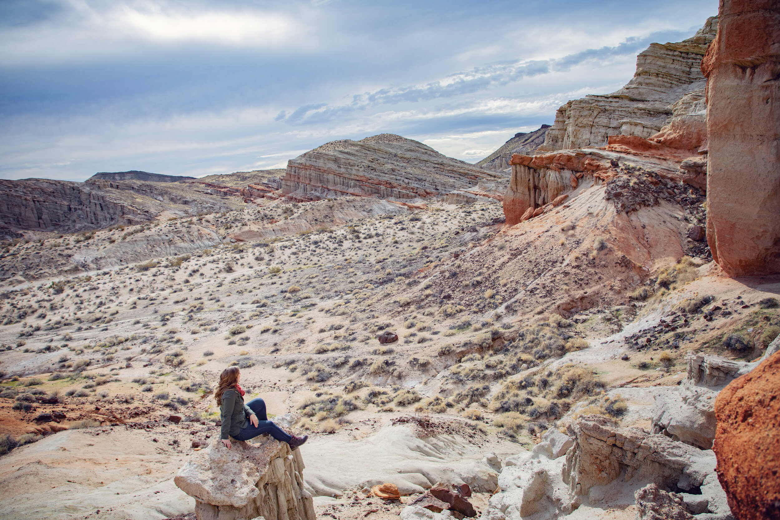
Red Rock Canyon State Park is a hidden gem along California’s high desert corridor, where towering sandstone cliffs, painted badlands, and wind-sculpted rock formations create an otherworldly desert landscape that feels straight out of a science fiction film. Located where the Sierra Nevada mountains meet the Mojave Desert, this state park offers a stunning contrast of red and cream-colored cliffs, making it a favorite for photographers, geology enthusiasts, and anyone looking for unique hiking trails in California’s desert parks. Whether you’re driving through on Highway 14 or planning an overnight camping trip, Red Rock Canyon is a must-stop destination on any California desert road trip itinerary.
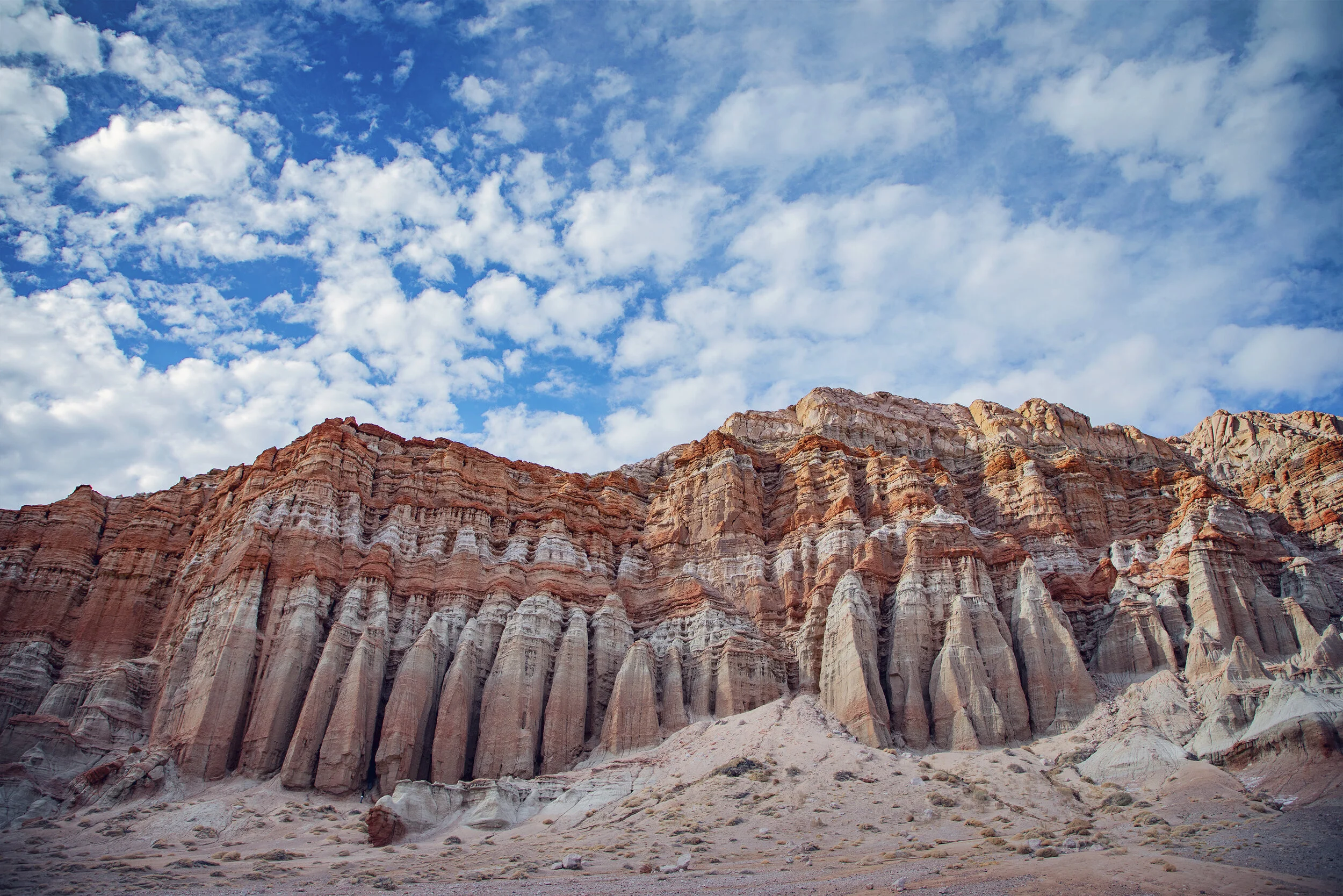
Red Cliffs at Red Rock Canyon State Park
Things to Do in Red Rock Canyon State Park
• Hiking: Hike the short and scenic Hagen Canyon and Red Cliffs Nature Trails with plenty of dramatic rock formations
• Camp Under the Stars: The park's skies are wonderfully dark and great for astrophotography.
• Photography Paradise: Early morning and sunset light bring out the richest colors.
Visitor Tips
• Entry Fee: $6 per vehicle for day use.
• Best Time to Visit: Fall through spring — summers can be brutally hot.
• What to Bring: Plenty of water, good hiking shoes, and a wide-angle lens for your camera.
Where to Stay
• Ricardo Campground: Located inside the park, 50 primitive sites are first come-first serve with picnic tables and fire rings.
• Mojave Hotels: The nearby town of Mojave offers basic hotels, including the Best Western Desert Winds.

Kia Sorrento at Trona Pinnacles in Searles Valley
🚗 Drive to Trona Pinnacles
About 90 minutes, ~80 miles
The drive to our next stop takes you through Mojave Desert landscapes, with sparse but beautiful views of volcanic hills and open desert. You'll follow Highway 14 north, then merge onto Highway 395, and take Trona Road toward Searles Lake. The final stretch to the pinnacles is a graded dirt road, so check conditions prior to visiting. High clearance vehicles are highly recommended.


Exploring the tufas at Trona Pinnacles
📍 Stop 2
Trona Pinnacles
The Trona Pinnacles feel like stepping onto the surface of an alien planet, and for good reason — these ancient tufa spires, some reaching up to 140 feet tall, were formed underwater in an ancient lakebed. Today, they rise dramatically from the dry earth, forming a truly alien desert landscape that has served as a backdrop for numerous Hollywood sci-fi films, commercials, and TV shows. This remote area, managed by the Bureau of Land Management (BLM), is perfect for dark sky stargazing, Milky Way photography, and off-the-beaten-path exploration for travelers looking for unique desert locations in California. Whether you’re looking for free camping near Ridgecrest or a bucket list stop on a California desert loop, the Trona Pinnacles deserve a spot on your itinerary.

Trona Pinnacles in Searles Valley
Things to Do at Trona Pinnacles
• Explore the formations: Wander through clusters of towers up to 140 feet tall.
• Stargazing: This is prime territory for Milky Way shots.
• 4WD Adventures: Many side trails offer a rugged drive.
Visitor Tips
• Entry Fee: None – BLM-managed public land.
• Road Conditions: The 5-mile road leading to the pinnacles is gravel and washboarded. High-clearance vehicles are recommended. I’ve only visited in an SUV, but I’ve heard sedans can make it with caution when conditions are good.
• Best Time to Visit: Fall through spring for comfortable weather. Desert wildflowers can be beautiful here in the spring after wet winters.
Where to Stay
• Primitive Camping at Trona Pinnacles: Free dispersed camping right next to the towers.
• Ridgecrest Hotels: The nearby town of Ridgecrest offers basic hotels, including the SpringHill Suites Ridgecrest.

Kia Sportage in Death Valley National Park
🚗 Drive to Death Valley
About 2 hours, ~90 miles
From Trona, follow Trona Road north to Panamint Valley Road — a gorgeous drive through desolate desert landscapes. You’ll enter Death Valley National Park from the western side, which is far less crowded than the east. Be on the lookout for burros! These non-native descendants of the burros brought here by early pioneers are often seen along this drive.

Zabriskie Point badlands in Death Valley National Park

Mesquite Flat Sand Dunes in Death Valley National Park
📍 Stop 3
Death Valley National Park
Death Valley National Park is the ultimate destination for travelers craving extreme landscapes and surreal desert beauty. Known as the hottest place on Earth, Death Valley’s terrain is a mesmerizing mix of salt flats, golden sand dunes, colorful canyons, jagged mountain ranges, and vibrant badlands, making it one of the most photogenic national parks in the United States. From the iconic views at Zabriskie Point to the vast expanse of Badwater Basin — the lowest point in North America — every corner of this park offers an opportunity to witness nature at its most raw and dramatic. Whether you’re a landscape photographer, adventure traveler, or just want to cross Death Valley scenic drives off your bucket list, this park is an essential stop on your California desert road trip.

Badwater Basin salt flats at sunrise in Death Valley
Things to Do in Death Valley
• Zabriskie Point: Epic views of golden badlands.
• Badwater Basin: Walk on salt flats at 282 feet below sea level.
• Mesquite Flat Sand Dunes: Perfect for golden hour photos.
• Artists Palette: See vibrant mineral-streaked hills.
• Dante’s View: Sweeping cliff-top panoramas of the entire valley.
Visitor Tips
• Entry Fee: $30 per vehicle (good for 7 days).
• Best Time to Visit: November through March. Summer travel in Death Valley is not recommended.
• What to Bring: Sun protection, extra water, and a reliable GPS device with pre-downloaded maps (cell service is minimal)...I recommend Gaia GPS for iPhone and Android.
Where to Stay
• Furnace Creek Campground: Centrally located with reservable sites.
• The Ranch at Death Valley: Historic family-friendly lodging with a pool.
• Panamint Springs Resort: Rustic but scenic option.

Artist’s Palette in Death Valley National Park
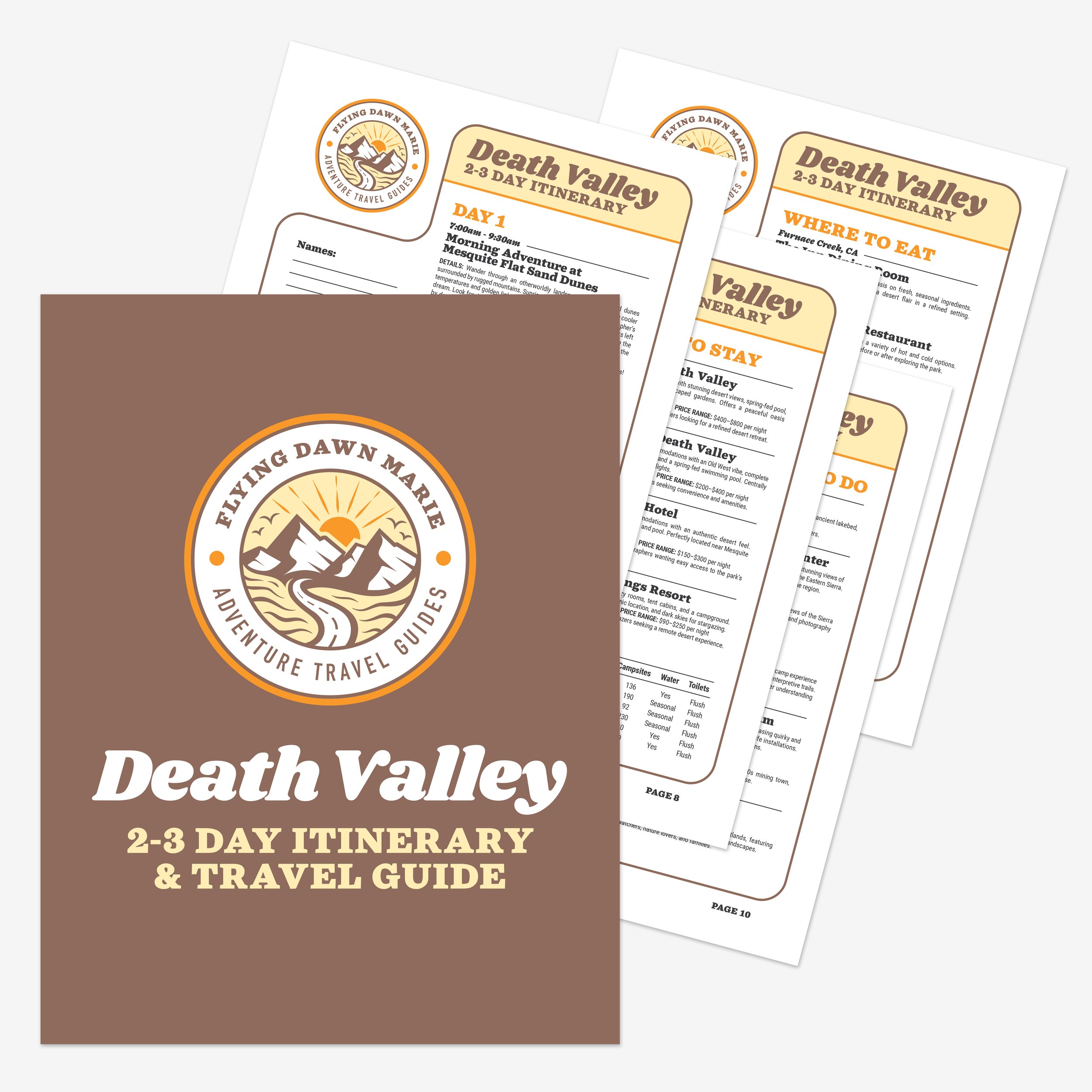
Death Valley 2-3 Day Itinerary & Travel Guide
If you’re planning a multi-day road trip to Death Valley, make sure to download my complete Death Valley 2-3 Day Itinerary & Travel Guide, which includes an hour-by-hour schedule, Google & Apple map pin locations, the best stargazing spots, a complete dining guide, recommendations on where to stay, desert safety guide, and more!

Alabama Hills near Lone Pine, CA
🚗 Drive to Alabama Hills
About 2.5 hours, ~130 miles
Leaving Death Valley, head west on Highway 190, climbing up into the Inyo Mountains before descending into Owens Valley. The Alabama Hills lie just west of Lone Pine along Highway 395, framed by the towering Sierra Nevada.

Mt. Whitney seen through Mobius Arch in Alabama Hills
📍 Stop 4
Alabama Hills
The Alabama Hills, just outside Lone Pine, California, offer a jaw-dropping collision of rugged desert beauty and high alpine grandeur. Framed by the towering peaks of the Sierra Nevada, including Mt. Whitney, the tallest peak in the lower 48 states, the Alabama Hills National Scenic Area features a labyrinth of rounded granite boulders, arches, and unique rock formations perfect for photography, rock climbing, and hiking. This area has starred in countless Western movies, and today, it’s a favorite destination for vanlifers, photographers, and road trippers exploring Eastern California’s desert treasures. If you’re looking for free camping near Lone Pine with epic sunrise views or the chance to explore famous movie locations in the California desert, the Alabama Hills won’t disappoint.

Otherworldly rock formations at Alabama Hills
Things to Do at Alabama Hills
• Mobius Arch Loop Trail: Short scenic hike to the most iconic formation in the region.
• Photograph Mt. Whitney: Seen throughout the area, but framed perfectly through Mobius Arch.
• Drive Movie Road: Featured in countless Westerns over the years, as well as fan favorites like Iron Man and Tremors.
• Rock scrambling and bouldering:
Visitor Tips
• Entry Fee: None – BLM-managed public land.
• Camping: Free dispersed camping is allowed, but it’s being regulated more to protect the landscape.
• Best Time to Visit: Spring and fall are ideal. Early Spring you’ll likely enjoy views of Mt. Whitney and the Sierra Nevada snow-capped.
• Vehicles: Most sedans can drive safely along Move Road, which is mostly gravel, however several other roads in the region require high clearance vehicles.
Where to Stay
• Alabama Hills: Free dispersed camping.
• Tuttle Creek Campground: Developed BLM campground nearby.
• Dow Villa Motel: A charming, historic stay in Lone Pine, CA.

Red Hill near Fossil Falls along Highway 395
🚗 Drive to Fossil Falls
About 1 hour, ~50 miles
Head south on Highway 395, passing ancient lava fields and the windswept desert floor. Fossil Falls is certainly worth a stop to explore the remnants of ancient volcanic activity, but it’s easy to miss. Look for the distinctive Red Hill located just to the north.
Fossil Falls in Owens Valley
📍 Stop 5
Fossil Falls
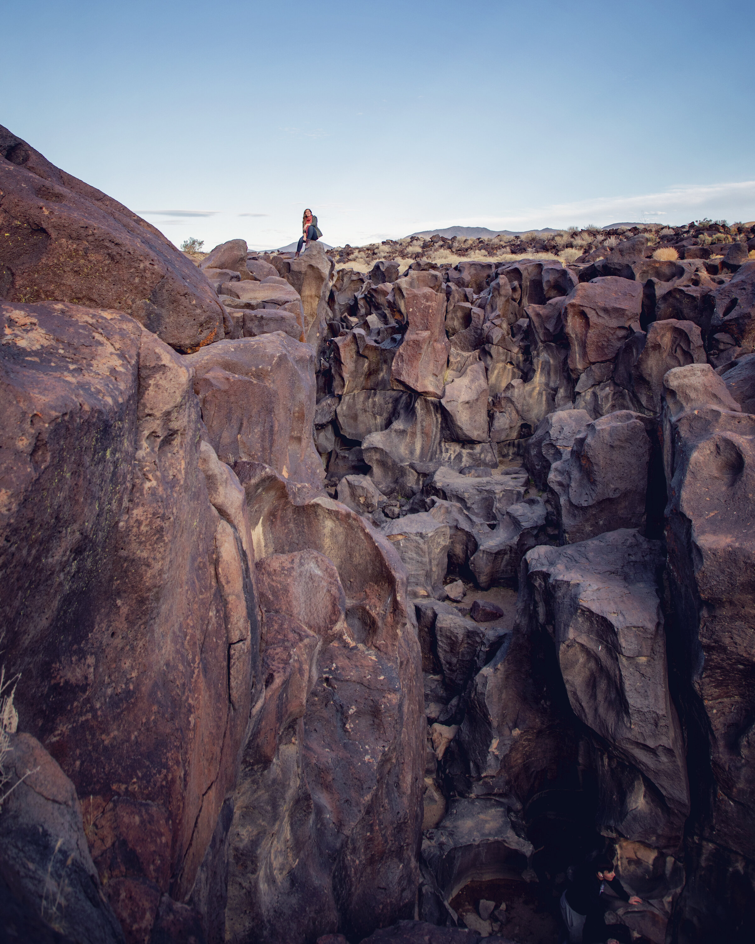
Although Fossil Falls doesn’t actually have a waterfall, this ancient volcanic wonder is one of California’s most intriguing geological sites, where glacial meltwater once carved a surreal, sculpted lava landscape. The smooth, black basalt formations at Fossil Falls Recreation Site look almost like modern art, shaped by the forces of volcanic eruptions and rushing water thousands of years ago. Today, this off-the-beaten-path stop along Highway 395 offers a short, scenic hike to a dramatic drop-off with panoramic views, making it an ideal place to stretch your legs on a California desert road trip. Whether you’re interested in California’s volcanic history, unique natural landmarks, or just want a quick Instagram-worthy photo stop, Fossil Falls is a must-see.

Volcanic rocks in the Fossil Falls area
Things to Do
• Walk to the Falls: It’s a quick, easy trail.
• Rock Climb: Climbers will find unique routes along the unique formations.
• Hike Red Cinder Mountain: Hike to the top of nearby Red Cinder Mountain (aka Red Hill), a dormant volcanic cinder cone.
Visitor Tips
• Entry Fee: None – BLM-managed.
• Best Time to Visit: Spring through Fall.
• What to Bring: Sturdy shoes for walking on uneven volcanic rock.
Where to Stay
• Fossil Falls Campground: Basic BLM sites with picnic tables and fire rings (first come, first served).

Astrophotography at the flooded Badwater Basin after a storm
Know Before You Go
• Trip Length: The total distance of this otherworldly terrain road trip is approximately 450-500 miles, depending on side trips. I’d recommend 4-5 days for a relaxed pace.
• Gas Up Often: Services are sparse between stops, so top off your tank when you can.
• Know Your Vehicle: High clearance vehicles are recommended in many of the areas listed in this post. Know what your vehicle’s limitations and only explore within those limitations.
• Download Maps: Cell service is unreliable in this region, so bring a reliable GPS device with pre-downloaded maps. I love using Gaia GPS for iPhone and Android devices.
• Hydration: Make sure to bring plenty of water on your trip. These locations are unforgiving and can get brutally hot. Anytime you hike in these areas, bring twice as much water as you think you’ll need.
• Check Weather & Road Conditions: It’s extremely important to check weather forecasts and road conditions prior to heading out on a desert adventure, especially when visiting Death Valley and Trona Pinnacles. Here are links to the official websites, which provide the most up-to-date park information: Red Rock Canyon State Park, Trona Pinnacles, Death Valley National Park, Alabama Hills, Fossil Falls.
• Leave No Trace: Although they look rugged, these are fragile landscapes, so please remember to follow all the Leave No Trace principles.

Exploring Trona Pinnacles
In Summary
Thanks so much for joining this me this week in California’s otherworldly desert terrain. For a virtual visit of all these stops, make sure to watch my Behind the Blog video located at the top of this post, or watch it on YouTube here. Until next week, I hope you find adventure and encouragement wherever you go.

Burros in the Panamint Valley near Death Valley National Park
Downloadable Itineraries & Travel Guides

If you enjoyed this post, you might also like…


About Me
I’m Dawn Marie, a travel and lifestyle blogger based out of Southern California. With in-depth articles, travel guides, and reviews on hotels & products, I seek to share my journeys to help you plan for your own. My adventures take me all over California, the western United States, and around the globe...and every Monday I post new content here, including a comprehensive blog post and YouTube video.
Search the Blog
Featured Posts


Etsy Shop
